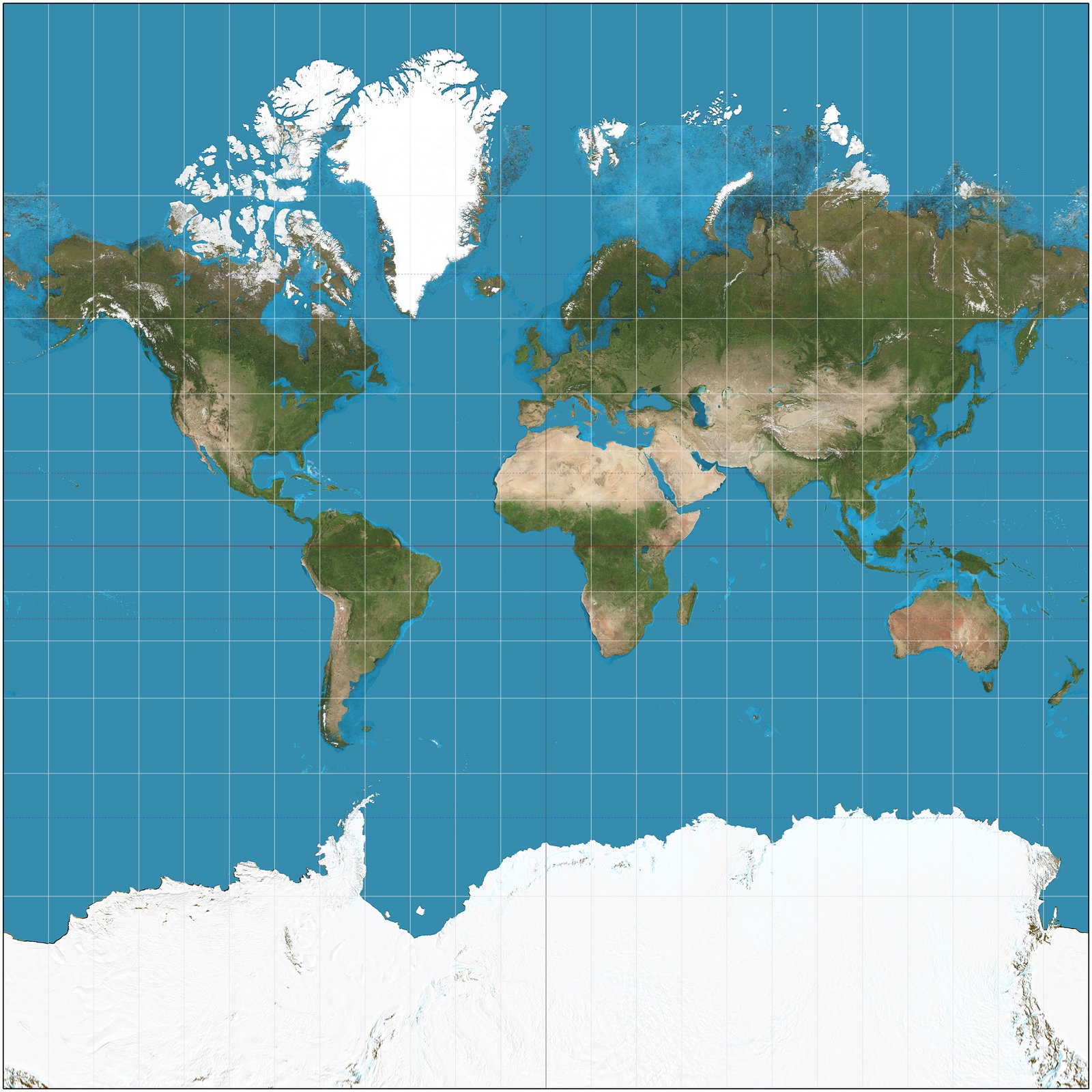

Have you ever looked at a world map and felt like something was just… off? Maybe you’ve stared at Greenland and thought, “Wait, that’s as big as Africa?” Well, you aren’t losing your mind—and you aren’t the only one who has noticed. The world of cartography is currently undergoing a major shakeup that has everyone talking.

📑 Table of Contents
The classic Mercator projection, which has been hanging in classrooms and glued to our digital navigation tools for centuries, might be getting a formal retirement notice. The UN is set to vote on a resolution that could change how we visualize our planet forever.
1. Mercator: Breaking Story & Core Details
It sounds like the plot of a documentary, but this is happening in real-time. Togo has officially sponsored a resolution at the UN General Assembly calling for the world to move away from the traditional Mercator map.
For those of us who grew up with it, the Mercator projection is basically “the” map. But the issue is all about scale. Because it was designed for sailors in the 1500s, it severely distorts the size of landmasses, making those closer to the poles look massive while shrinking continents like Africa. The proposal aims to swap this outdated model for one that accurately reflects the true size of the African continent.
2. Key Facts, Timeline & What Happened
Here is the breakdown of why this shift is creating such a buzz:
- The Sponsor: The resolution is being led by Robert Dussey, Togo’s foreign affairs minister, with backing from all 54 African Union member states.
- The Motivation: Dussey insists this isn’t a political move, but a scientific one. He believes it’s time for the world to accept the physical reality of our geography.
- The Inventor: The projection was created way back in 1569 by Flemish cartographer Gerardus Mercator to help sailors navigate the open seas.
- The Impact: While UN resolutions aren’t legally binding laws, a “yes” vote would likely trigger a massive shift in how textbook publishers, tech giants, and educational systems display maps globally.
🔥 Trending on JattFlix Right Now:
3. In-Depth Context & Celebrity Background
You might be wondering: why does a 500-year-old map still matter in our high-tech era? It’s because the Mercator projection is baked into the DNA of our modern digital life. From Google Maps to the GPS in your car, the math behind the original projection has stayed relevant because it’s so good at keeping navigation lines straight.
However, the “cost” of that convenience is the distortion of landmasses. Africa, in reality, is huge—it’s roughly 14 times larger than Greenland. Yet, on most classroom maps, they look almost identical in size. It’s an optical illusion that has skewed our global perception for five centuries.
4. Fan Reactions & Social Media Reception
The internet has been having a field day with this news. If you head over to social media, you’ll see two distinct camps.
One side is absolutely shocked, with many users posting, “I genuinely thought Greenland was massive my entire life!” Others are applauding the UN, saying it’s long overdue to modernize our curriculum. There is a lot of excitement from educators who are ready to ditch the old posters for more accurate, “equal-area” projection maps.
5. What This Means & What’s Next in 2026
So, what happens if this passes? If you are a fan of OTT & New Release content, expect to see this debate pop up in documentaries and educational programming over the next few years. If the world starts moving away from the standard projection, we’ll see a slow but steady update to our favorite apps and interactive globe software.
At JattFlix, we’re keeping a close watch. This is the kind of massive cultural shift that usually takes a few years to fully integrate into our digital interfaces, so 2026 is shaping up to be a big year for cartography fans and geography buffs alike.
6. Frequently Asked Questions (FAQs)
Q: Why is the Mercator map considered “wrong”?
A: It isn’t “wrong” for navigation, but it is “wrong” for scale. It distorts the size of countries near the poles while minimizing regions near the equator.
Q: Will my GPS stop working if they change the map?
A: Not at all! Navigation software is mostly about mathematical coordinates. Changing the visual representation of a map is just a design choice that sits on top of that math.
Q: Who is Gerardus Mercator?
A: He was a 16th-century Flemish cartographer who invented the projection that bears his name in 1569.
Q: Is this legally binding for all countries?
A: No. UN resolutions are generally non-enforceable, but they hold significant weight in setting global standards for education and public policy.
7. Final Thoughts & Your Take
It’s wild to think that a map we’ve stared at since grade school might finally be getting an update. Whether you’re a geography nerd or just someone who hates being lied to by a classroom poster, it’s a fascinating time to watch history (and geography) being made.
What do you think? Should we stick to the classic Mercator for the sake of tradition, or is it time for a total refresh? Drop a comment below and let us know your take—we love hearing from you!